Trans America Trail - 2008
Pre ride Journal.
T minus 119 days. (30.01.2008)
I’m starting this journal as my wife said it would be good to look
back over the experience and see how it all went and what I was feeling at the
time. She’s good like that; she’s got loads of good ideas.
So, what is this all about.
I’ve been planning a thing called the Trans-America Trail for over
2 years now. The TAT, as we call it, is an off road ride across the
Sam had the idea to create an off road route that stayed away from
pavement (or asphalt as the Americans like to call it) and allowed the rider to
experience the
Why do it?
Don’t know. It just appealed. Before leaving
There was an article in the BIKE magazine in the
So where am I today, 119 days before I start the trail? Something like this…
·
I have sent 3000 pounds
over to my Aunty in the
·
I’ve investigated getting
insurance through Geico and Progressive via my
cousin. John is more of the riding age, I will then be
set as a named ‘operator’. The cost is about 400US$ for the year with all
options maxxed out.
·
I’ve numerous pieces of
kit all ready to go, this includes my riding gear:
o
New MX boots
o
New Akito
riding jacket and pants(waterproof)
o
New helmet (Used, but
almost new)
o
New Alpinestar
gloves
·
Kit for the bike (all of
this is lifted out of a project planner):
o
New Touratech road book
holder
o
GPS – etrex
Vista Cx
o
New touratech
Etrex bar mount
o
o
New oxford tail bag
o
Various bunji cords and straps
o
Standard diameter Renthal
handlebar
o
Acerbis Rally-Pro hand
guards
o
Renthal grips & glue.
o
16 tooth front sprocket
(standard=15)
o
Numberplate protection
o
2 x 1L fuel bottles
o
Take fuel clamps and
lines
o
Audible Alarm and cable
lock
o
City Navigator for
o
Modify crossbar to take Roadbook
o
Modify crossbar to take
GPS mount
o
Modify crossbar to take
Endurance Computer
o
Modify crossbar to attach
map holder
o
Modify crossbar for
removal
o
Fender bag (front)
o
Rear fender bag
o
Tank bag
o
Levers
o
Spokes (1 X Front, 2 X
Rear)
o
Spare air filter
o
Spark plug
o
Bulbs
o
Service Kit
o
Fuses
o
Tubes
o
1 liter oil
o
Oil Filter
o
Nitril gloves
o
Zip ties
o
Epoxy glue
o
JB Weld (metal glue)
o
Hose clamps
o
Master link(s)
o
Chain lube
o
Spare ignition key
o
Assorted nuts and bolts
o
Loctite
o
AA rechargeable batteries
(X8)
o
Cell Phones and car
cigarette chargers
o
Electric Power
o
Hidden holder
o
Emergency rations?
o
Lighter
o
LED Latern
o
Journal & Pen
o
Camera and SD cards
o
Sat Phone
o
Tent
o
Ground roll
o
Sleeping bag
o
Imodium
o
Broad spectrum
antibiotics
o
Antiseptic gel
o
Aspirin / Paracetemol / Tramadol
o
Dressings and bandages
o
'Roid
cream
o
Scalpel & blades
o
Needle and Thread
o
Toilet paper
o
Razor / Scissors
o
Comb
o
Sunscreen
o
Lip balm
o
Soap
o
Shampoo
o
Deodorant
o
Moisturizer
o
Tools
o
2 X
o
1 X Combo tyre lever
o
Puncture repair kit
o
Allen keys
o
Hacksaw Blade
o
Pliers / Side cutters
o
o
Tow rope
o
Combo screwdriver
o
Combo sockets
o
Jumper cables
o
Siphon tube
o
Duct tape
o
Wet wipes
o
File
o
Spyderco Knife
o
Enduro Jacket
o
Gore-Tex Trouser 1
o
Gore-Tex Trouser 2
o
Inner Gloves
o
Off-road gloves
o
Boots
o
Casual shoe
o
Helmet
o
Goggles
o
Quick straps
o
Kidney belt
o
Camel-bak
and rucksack + extra 2 litre
o
Elbow and Knee protection
o
Neck tube
o
Ear plugs
o
Lycra riding boxers X 3
o
Sunglasses
o
G-Shock or similar watch
o
Fleece
o
2 pair zip off trousers
o
2 riding jerseys
o
3 socks
o
3 briefs
o
2 t-shirts
o
Train
o
Documents
o
Insurance docs for
o
Doctor
So LOADS of stuff, but hopefully it won’t snap the frame.
T minus 117 days. (01.02.2008)
Road books have been received as well as maps from Sam. I’m now in
the process of making sense of these.
Sam created road books, kind of a turn-by-turn instruction sheet
printed on a till roll, and used survey maps for reference which he provides
(for US$ 276.00) to each prospective rider. The road books come on A4 paper in
three columns that need to be cut and taped together to fit into the road book
holder. This device is essentially an aluminum box with a clear Perspex top
that has two spindles with rollers to feed the strip of paper across underneath
the Perspex. As you ride along the directions are indicated something like:
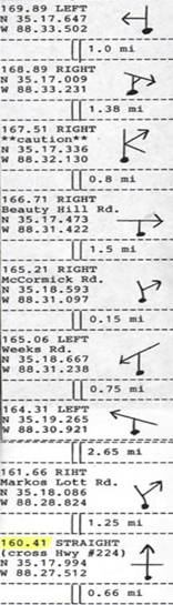
These are read (from the bottom) as follows:
·
Ride 0.66 miles and
you’ll approach a crossing at 160.41 miles total trip distance.
·
At the crossing you’ll
ride straight over highway #224
·
The GPS co-ordinates are listed
for the crossing.
So fairly simple then? Well
sort off, there are a few concerns:
·
There’s a finite capacity
that the road book holder can take and there’s about 100 meters of 50mm wide
road book. So this will have to be swapped out. Swapping the road book is
fiddly and time consuming, and it’s NOT something to be done on the trail as
sods law indicates that a road book change will be necessary in the middle of a
torrential downpour. So I need to construct the sections in conjunction with
the days riding, this will allow a change at the motel (where’s its nice and
warm)
·
The biggest worry of
course is that if you miss one instruction or read it wrong then EVERY one
thereafter will be out. So I have to hit every one. This isn’t as bad as it
seems – I have maps that I can use to get around flooded areas and downed
bridges and I also have a GPS, but the chances of these road books being
accurate over the entire 5000 miles is slim. Dirt roads are always being tarred
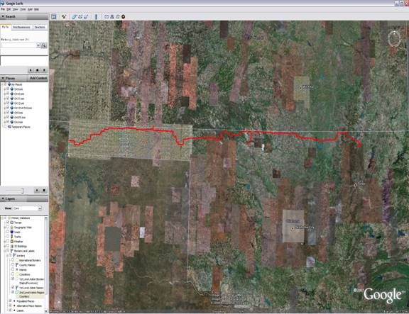
and redirected. So to get around this I’m using Google Earth to look at the
route and create routes that I can load into my GPS.
Google earth can save routes as simple waypoints on a map. These can then be
exported from the computer as KML files and then ran through a converter to
make XML files. XML files can also be saved as GPX files which is a GPS device
format. These can then be loaded into the GPS and will show themselves as a
breadcrumb trail on the display. If I do this for the entire trail I will be
able to verify the route and have a backup for the road book and maps. It might
take a while however. I’ve done
T minus 90 days. (28.02.2008)
Been a while since this was updated so best write some stuff in
here.
90 days to go, that brings things home a bit.
Seems like there’s loads of stuff to do and now there’s not
time to do it. Getting the maps all sorted is taking forever – the
process is:
·
Map the route in GE as
per the printed maps Sam has sent. There are up to 16 of these maps per state
and sometime they are not very clear!
·
Break up the KML files
created by GE so that there are no more than 500 waypoints in each file. My
Garmin GPS can only handle files with this number and there’s a limitation of
10,000 waypoints in total. When I did
·
Load the KML files into GPSbabel and create GPX files. GPSBabel
is an app that converts files to the GPS format (.gpx).
which can then be loaded into the Garmin. This will
then take the city navigator info on the SD card that I bought but as I’m using
all 20 tracks (with 500 waypoints each = 10,000) I won’t be able to use the ‘tracback’ function of the GPS. This is a breadcrumb trail
that feature that helps you retrace your steps in case you get lost. A nice feature…
hopefully I won’t need it…
That’s it for the GPS.
·
Update the maps with co-ords. The maps show mileage checkpoints based on a
cumulative total. These are listed about every 30-40 miles. I want to add
long/lat co-ords on top of these to be 100% sure. Unfortunately
GE displays the grid co-ords in
degrees/minutes/seconds but the GPS (and the road-book) runs in
degrees/minutes/decimal seconds. So I’ll have to convert all of these too.
·
Update the maps with
motel information. Phone numbers and alternatives in case they are full.
·
Update the maps with
Suzuki dealers. In case the bike goes pop or I need any other spares.
·
Cover the maps with
waterproof adhesive film. In case they get wet. I’d like to put them back to
back too so as to cut down on the number.
My cousin John has managed to get the bike sorted yesterday. The
dealer has one on order now, should be about 2 weeks. Closer to the time,
probably beginning of May he put a title on it (assume this means register it
in his name) and get the insurance sorted. The insurance was a real worry but
he went through his agent and got that all sorted. Great.
There’s a new video out on the roadlesstraveled
website:
There’s also a forum on the official TAT website that I’m a member
of now. It’s not as good as springTAT but will pick
up eventually I think.
Paul Howey – the
T minus 78 days. (07.03.2008)
Maps are almost done now. I’ve added the GPS co-ordinates to the check
points as well as three motels at each stop point. The stop points are quite
interesting; there’s a few places in
On the downside I’m going to go in for a
arthroscopy on the 7th of April. This is not something I planned for
and I hope nothing serious comes of it. This is due to coming off the snowboard
in
The Endurance Speedo I bought from trail-tech is causing some
concerns as I need to figure out how to use it! Its
pretty complicated but will help in on the ride as I can increment AND
decrement the waypoint running totals. A normal Speedo cannot do this.
T minus 23 days. (01.05.2008)
Been a while since the last update. Work has been crazy busy so instead of being able to type these
updates I’ve been up to the eyeballs in scripts and database updates..
So, knee operations went fine and strength is coming back slowly
but surely. Started cycling on the road again last weekend and am trying to go
to gym 5 days a week now.
Got all the presents for my in-laws in the
Ordered the SAT phone and that will be shipped to Bob Campbell.
Also ordered some spares from the Suzuki dealer which as necessary on the trip.
Couldn’t get any spokes though so I need to keep checking them.